Morphological properties of typifying pedon.
|
|
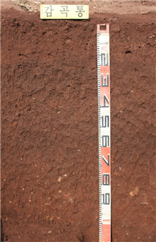
GAMGOG SERIES |
Established Series PCS, JYH, UKT 28 Mar. 1977 |
The Gamgog series are members of the fine loamy, mixed, mesic family of Typic Hapludalfs [Cutanic Luvisols (Hypereutric Rhodic) classified by WRB]. These soils have reddish brown gravelly sandy loam Ap horizons, dusky red gravelly loam BA horizons, dark reddish brown gravelly clay loam Bt1 horizons, reddish brown gravelly clay loam Bt2 horizons. The Gamgog soils occur on local valleys derived from red shale materials.
Typifying Pedon: Gamgog gravelly silt loam-red pepper (Colors are for moist soil).
Slope: 2-7%
Elevation: 130 m above m.s.l.
Soil moisture regime: Udic
Soil temperature regime: Mesic
Parent material: All-colluvium from red shale materials
Diagnostic features: An ochric epipedon from a depth of 0 to 18 cm and an argillic horizon from a depth of 18 to 145 cm (An Argic horizon from a depth of 18 to 145 cm by WRB).
Described by: Song, K. C., D. C. Noh, and B. K. Hyun, 6 March, 2013.
|
|
|
|
|
Morphological properties of typifying pedon. |
||
Ap - 0 to 18 cm. Reddish brown (2.5YR 4/3) gravelly sandy loam; moderate medium to coarse granular structure; friable, sticky and plastic; many fine to medium roots; common fine pores; few very fine micas; 15% fine gravels; clear smooth boundary.
BA - 18 to 47 cm. Dusky red (2.5YR 3/2) gravelly loam; moderate medim subangular blocky structure; slightly firm, sticky and plastic; thin patch clay cutans; few fine roots; common fine to medium pores; few very fine micas; few worm holes; 20% fine gravels; gradual smooth boundary.
Bt1 - 47 to 71 cm. Dark reddish brown (2.5YR 3/3) gravelly clay loam; weak medium to subangular blocky structure; firm, sticky and plastic; thin patch clay cutans; few very fine roots; common few fine to medium pores; few very fine micas; few worm holes; 15% gravels; clear wavy boundary.
Bt2 - 71 to 145 cm. Reddish brown (2.5YR 4/3) gravelly clay loam; moderate coarse subangular blocky structure; very firm, sticky and plastic; thick continuous clay cutans; few very fine roots; common fine to medium pores; 25% gravels.
The typifying pedon has an ochric epipedon from a depth of 0 to 18 cm and an argillic horizon from a depth of 18 to 145 cm. It has a base saturation (by sum of cations) of 35% or more at 125 cm below the upper boundary of the argillic horizon. That can be classified as Alfisol. It has an udic soil moisture regime, and can be classified as Udalf. It meets the requirements of Typic Hapludalf.
The typifying pedon has in the fraction less than 75 mm in diameter, 15% or more particles with diameters of 0.1 to 75 mm and in the fine-earth fraction, 18 to 35% clay at the particle-size control section and has mesic soil temperature regime. Therefore it can be classified as fine loamy, mixed, mesic family of Typic Hapludalf.
Type Location: About 300 meters west of Incheon Branch School of Changsu Elementaty School, Incheon Ri, Changsu Myeon, Yeongdeog Gun, Gyeongsangbug Do (129o 17' 31.0'', 36o 38' 8.5'').
Range in Characteristics: These soils have ochric epipedons and argillic horizons. The solum thickness ranges from 100 to 150 cm and depth to hard rock is probably more than 3 meters. Base saturation is more than 60 percent. Reaction is medium acid to neutral. These soils contain 10 to 35 percent slightly weathered reddish brown shale gravels. Ap horizons are dark reddish brown, reddish brown, or brown gravelly loam, silt loam, or sandy loam. The argillic B horizons are dark reddish brown or reddish brown gravelly silty clay loam or clay loam.
Competing Series and Their Differentiae: These are the Heugseog, Galjeon, and Banho soils. The Heugseog soils are derived from phyllite or dark colored schist materials. The Galjeon soils occur on mountain foot slopes in anorthosite geology. The Banho soils are formed on local alluvial fans in materials washed from grayish brown shale materials.
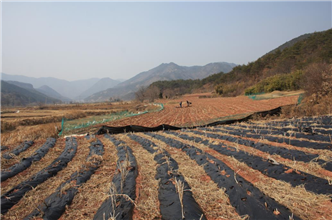
Setting: The Gamgog soils are on gently sloping to moderately steep local valleys in materials washed from the reddish brown shale. Dominant slopes are 2 to 15 percent and range from 2 to 30 percent.
Principal Associated Soils: The Habin, Gwisan, and Buyeo soils are associated in residual upland positions. The Samam and Maryeong soils are associated in local valleys and narrow alluvial plains at lower elevations.
Drainage and Permeability: Well drained; moderate permeability; medium runoff.
Use and Vegetation: Most of these soils are used for upland crops such as barley, soybean and red pepper.
Distribution and Extent: The Gamgog soils are of small extent and are distributed in red shale rock areas of southern parts of the country.
Series Established: Jinju city, Gyeongsangnam Do, 1975. Revised, Yeongdeog Gun, Gyeongsangbug Do, 2013.
Laboratory data sheets of typifying pedon.
|
Depth (cm) |
Horizon |
( --- Total ---) |
(-- Clay --) |
(-- Silt --) |
(------- Sand -------) |
||||||||
|
Clay |
Silt |
Sand |
Fine |
Coarse |
Fine |
Coarse |
VF |
F |
M |
C |
VC |
||
|
LT |
.002 |
.05 |
LT |
LT |
.002 |
.02 |
.05 |
.10 |
.25 |
.5 |
1 |
||
|
.002 |
- .05 |
- 2 |
.0002 |
.002 |
- .02 |
- .05 |
- .10 |
- .25 |
- .50 |
- 1 |
- 2 |
||
|
- - - - - - - - - - - Pct of ˂ 2mm (3A1) - - - - - - - - - - - |
|||||||||||||
|
0-18 |
Ap |
17.1 |
41.6 |
56.2 |
|
|
12.3 |
29.3 |
6.4 |
15.7 |
14.7 |
13.0 |
6.4 |
|
18-47 |
BAt |
24.6 |
32.0 |
44.0 |
|
|
16.0 |
16.0 |
5.9 |
12.5 |
11.5 |
9.8 |
4.3 |
|
47-71 |
Bt1 |
27.0 |
36.7 |
37.1 |
|
|
18.2 |
18.5 |
5.8 |
10.2 |
9.5 |
8.5 |
3.2 |
|
71-145 |
Bt2 |
26.6 |
39.9 |
34.1 |
|
|
20.9 |
19.0 |
5.0 |
9.1 |
8.5 |
7.4 |
4.0 |
|
Depth (cm) |
Coarse Fractions(mm) |
˃2mm |
Orgn |
Total |
Extr |
Total |
(-- Dith -Cit --) |
|||||
|
Weight |
Wt |
C |
N |
P |
S |
Extractable |
||||||
|
2-5 |
5-20 |
20-75 |
.1-75 |
Pct of |
|
|
|
|
Fe |
Al |
Mn |
|
|
|
|
|
|
Whole |
6A1c |
6B3a |
6S3 |
6R3a |
6C2b |
6G7a |
6D2a |
|
|
Pct of ˂ 75mm (3B1) |
Soil |
Pct ˂ 2mm |
g/kg |
Pct of ˂ 2mm |
||||||||
|
0-18 |
|
|
|
|
|
0.90 |
|
|
|
|
|
|
|
18-47 |
|
|
|
|
|
0.81 |
|
|
|
|
|
|
|
47-71 |
|
|
|
|
|
0.69 |
|
|
|
|
|
|
|
71-145 |
|
|
|
|
|
0.57 |
|
|
|
|
|
|
|
Depth (cm) |
Ratio/Clay |
Atterberg |
( Bulk Density ) |
COLE |
(- Water Content -) |
WRD |
|||||||
|
CEC |
1500 |
Limits |
Field |
33 |
Oven |
Whole |
Field |
10 |
33 |
1500 |
Whole |
||
|
|
kPa |
LL |
PI |
Moist |
kPa |
Dry |
Soil |
Moist |
kPa |
kPa |
kPa |
Soil |
|
|
8D1 |
8D1 |
4P1 |
4P |
4A3a |
4A1d |
4A1h |
4D1 |
4B4 |
4B1c |
4B1c |
4B2a |
4C1 |
|
|
|
|
Pct ˂0.4mm |
- - g/cc - - |
cm/cm |
-- Pct of ˂2mm -- |
cm/cm |
|||||||
|
0-18 |
0.43 |
|
|
|
1.44 |
|
|
|
11.8 |
|
|
|
|
|
18-47 |
0.44 |
|
|
|
1.60 |
|
|
|
14.3 |
|
|
|
|
|
47-71 |
0.48 |
|
|
|
|
|
|
|
|
|
|
|
|
|
71-145 |
0.40 |
|
|
|
|
|
|
|
|
|
|
|
|
|
Depth (cm) |
( NH4OAc Extractable Bases ) |
Acid- |
Extr |
(----- CEC -----) |
Al |
||||||
|
Ca |
Mg |
K |
Na |
Sum |
ity |
Al |
Sum |
NH4- |
Bases |
Sat |
|
|
5B5a |
5B5a |
5B5a |
5B5a |
Bases |
|
|
Cats |
OAc |
+ Al |
|
|
|
6N2e |
6O2d |
6Q2b |
6P2b |
|
6H5a |
6G9a |
5A3a |
5A8b |
5A3b |
5G1 |
|
|
- - - - - - - - - - - - meq / 100g - - - - - - - - - - - - |
Pct |
||||||||||
|
0-18 |
3.7 |
1.1 |
0.9 |
0.1 |
5.7 |
6.0 |
0.4 |
11.7 |
7.4 |
6.1 |
6.2 |
|
18-47 |
8.4 |
2.8 |
0.8 |
0.1 |
11.1 |
4.8 |
0 |
16.0 |
10.8 |
11.1 |
0 |
|
47-71 |
8.2 |
2.7 |
0.5 |
0.1 |
11.5 |
3.9 |
0 |
15.4 |
13.0 |
11.5 |
0 |
|
71-145 |
7.4 |
3.3 |
0.3 |
0.1 |
11.1 |
3.3 |
0 |
14.4 |
10.8 |
11.1 |
0 |
|
Depth (cm) |
(Base Sat) |
CO3 as |
Res |
Cond |
(------ pH ------) |
Acid Oxalate Extraction |
|||||||
|
Sum |
NH4- |
CaCO3 |
|
|
NaF |
KCl |
CaCl2 |
H2O |
Opt |
Al |
Fe |
Si |
|
|
|
OAc |
˂2mm |
|
|
|
|
.01M |
|
Den |
|
|
|
|
|
5C3 |
5C1 |
6E1g |
8E1 |
8I |
8C1d |
|
8C1f |
8C1f |
8J |
6G12 |
6C9a |
6V2 |
|
|
---- Pct ---- |
ohms/cm |
dS/m |
|
1: 1 |
1: 2 |
1: 1 |
|
- Pct of ˂2mm - |
|||||
|
0-18 |
48.9 |
77.8 |
|
|
|
|
4.1 |
4.5 |
5.0 |
|
|
|
|
|
18-47 |
69.7 |
100 |
|
|
|
|
5.3 |
5.8 |
6.4 |
|
|
|
|
|
47-71 |
74.8 |
97.4 |
|
|
|
|
5.6 |
6.3 |
7.0 |
|
|
|
|
|
71-145 |
76.9 |
100 |
|
|
|
|
5.8 |
6.6 |
7.4 |
|
|
|
|


