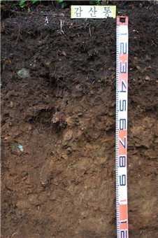
Morphological properties of typifying pedon.
|
|
GAMSAN SERIES |
Established Series PCS, JYH, UKT 10 Apr., 1977 |
The Gamsan series are members of the medial-cindery, ferrihydritic, thermic family of Typic Hapludands [Umbric Aluandic Andosols (Eutric) classified by WRB]. These soils have very dark grayish brown gravelly silt loam A horizons, very dark grayish brown gravelly loam AB horizons, dark yellowish brown very gravelly loam Bw horizons, dark yellowish brown very gravelly loam BC horizons, and brown very gravelly sandy loam C horizons. They occur on cinder cones derived from pyroclastic materials.
Typifying Pedon: Gamsan gravelly silt loam-forest (Colors are for moist soil).
Slope: 15-30%
Elevation: 75 m above m.s.l.
Soil moisture regime: Udic
Soil temperature regime: Thermic
Parent material: Pyroclastic materials
Diagnostic features: An umbric epipedon from a depth of 0 to 36 cm, a cambic horizon from a depth of 36 to 62 cm, and andic soil properties from a depth of 0 to 180 cm (An umbric horizon from a depth of 0 to 36 cm, a cambic horizon from a depth of 36 to 62 cm, and andic properties from a depth of 0 to 180 cm by WRB).
Described by: Song, K. C., D. C. Noh, and S. J. Jung, 17 June, 2011.
|
|
|
|
|
Morphological properties of typifying pedon. |
||
A - 0 to 18 cm. Very dark grayish brown (10YR 3/2) gravelly silt loam; weak fine to medium granular structure; friable, slightly sticky and slightly plastic; many fine to medium roots; common fine to medium pores; few coarse worm holes; 10% gravels; clear smooth boundary.
AB - 18 to 36 cm. Very dark grayish brown (10YR 3/2) gravelly loam; moderate fine to medium subangular blocky structure; friable, slightly sticky and slightly plastic; many fine to medium roots; common fine to medium pores; many worm holes; 15% gravels; clear smooth boundary.
Bw - 36 to 62 cm. Dark yellowish brown (10YR 3/4) very gravelly loam; weak fine to medium subangular blocky structure; friable, slightly sticky and slightly plastic; common fine to medium roots; many fine to medium pores; many worm holes; 35% gravels; clear wavy boundary.
BC - 62 to 80 cm. Dark yellowish brown (10YR 4/6) very gravelly loam; weak fine to medium subangular blocky structure; firm, slightly sticky and slightly plastic; few fine roots; few fine pores; 35% gravels; clear smooth boundary.
C - 80 to 160 cm. Brown (10YR 4/3) very gravelly sandy loam; structureless, massive; slightly sticky and slightly plastic; few fine roots; few fine pores; 40% gravels.
The typifying pedon has an umbric epipedon from a depth of 0 to 36 cm and a cambic horizon from a depth of 36 to 62 cm. That contains oxalate extractable (Al + 1/2Fe) content equal to 2.0 or more, phosphate retention of 85% or more, and bulk density of 0.90 g/cm3 or less from a depth of 0 to 62 cm. Therefore it has an andic soil properties at that depth. It can be classified as Andisol. It has an udic soil moisture regime, and can be classified as Udand. It meets the requirements of Typic Hapludand.
The typifying pedon has medial-cindery particle-size class, ferrihydritic mineralogy class and thermic soil temperature class. Therefore it can be classified as medial-cindery, ferrihydritic, thermic family of Typic Hapludand.
Type Location: Western entrance of the Maeoreum, Pyoseon Ri, Pyoseon Myeon, Seogwipo city, Jeju Do (126° 48' 35.5'', 33° 16' 45.6'').
Range in Characteristics: These soils have umbric epipedons, cambic horizons, and Andic soil properties. The solum thickness ranges from 50 to 100 cm and depth to hard rock is more than 3 meters. Reaction is medium to slightly acid. Base saturation is less than 60 percent. A horizons are very dark grayish brown or dark brown gravelly loam. The cambic B horizons are dark grayish brown or dark yellowish brown very gravelly silt loam or loam. C horizons are yellowish brown, strong brown, or dark yellowish brown very gravelly loam, silt loam or sandy loam.
Competing Series and Their Differentiae: These are the Bongseong, Jeogag, and Songag soils. The Bongseong soils occur on lava plains. The Jeogag soils occur on high elevated cinder cones and medial over cindery texture class. The Songag soils have medial texture class.
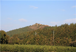
Setting: The Gamsan soils are developed on cinder cones and are derived from pyroclastic materials. Slope ranges from 7 to 60 percent and 15 to 30 percent slopes are predominant.
Principal Associated Soils: The Wimi, Euigwi, and Jeongbang soils are associated in lava plain positions. The Geumag, Miag, Nogsan, and Songag soils are associated in similar physiographic positions.
Drainage and Permeability: Well drained. Permeability is moderately rapid. Runoff is medium to rapid.
Use and Vegetation: Most of these soils are grown grass and forest.
Distribution and Extent: The Gamsan soils are of small extent and are distributed on cinder cones in Jeju, Do.
Series Established: Seogwipo city, Jeju Do, 1975. Revised, Seogwipo city, Jeju Do, 2011.
Laboratory data sheets of typifying pedon.
|
Depth (cm) |
Horizon |
( --- Total ---) |
(-- Clay --) |
(-- Silt --) |
(------- Sand -------) |
||||||||
|
Clay |
Silt |
Sand |
Fine |
Coarse |
Fine |
Coarse |
VF |
F |
M |
C |
VC |
||
|
LT |
.002 |
.05 |
LT |
LT |
.002 |
.02 |
.05 |
.10 |
.25 |
.5 |
1 |
||
|
.002 |
- .05 |
- 2 |
.0002 |
.002 |
- .02 |
- .05 |
- .10 |
- .25 |
- .50 |
- 1 |
- 2 |
||
|
- - - - - - - - - - - Pct of ˂ 2mm (3A1) - - - - - - - - - - - |
|||||||||||||
|
0-18 |
A |
21.9 |
45.3 |
32.7 |
|
|
16.8 |
28.5 |
5.0 |
11.5 |
7.5 |
5.9 |
2.8 |
|
18-36 |
AB |
23.5 |
41.6 |
34.8 |
|
|
17.3 |
24.3 |
5.8 |
13.3 |
8.3 |
5.2 |
2.2 |
|
36-62 |
Bw |
21.7 |
36.4 |
41.8 |
|
|
11.9 |
24.5 |
10.8 |
17.1 |
9.2 |
4.0 |
0.8 |
|
62-80 |
BC |
16.4 |
30.7 |
52.9 |
|
|
8.2 |
22.5 |
14.8 |
21.9 |
11.0 |
4.4 |
0.8 |
|
80-160 |
C |
10.3 |
20.5 |
69.2 |
|
|
3.2 |
17.3 |
10.9 |
22.5 |
16.6 |
13.3 |
5.9 |
|
Depth (cm) |
Coarse Fractions(mm) |
˃2mm |
Orgn |
Total |
Extr |
Total |
(-- Dith -Cit --) |
|||||
|
Weight |
Wt |
C |
N |
P |
S |
Extractable |
||||||
|
2-5 |
5-20 |
20-75 |
.1-75 |
Pct of |
|
|
|
|
Fe |
Al |
Mn |
|
|
|
|
|
|
Whole |
6A1c |
6B3a |
6S3 |
6R3a |
6C2b |
6G7a |
6D2a |
|
|
Pct of ˂ 75mm (3B1) |
Soil |
Pct ˂ 2mm |
g/kg |
Pct of ˂ 2mm |
||||||||
|
0-18 |
|
|
|
|
|
6.56 |
|
|
|
|
|
|
|
18-36 |
|
|
|
|
|
3.48 |
|
|
|
|
|
|
|
36-62 |
|
|
|
|
|
1.40 |
|
|
|
|
|
|
|
62-80 |
|
|
|
|
|
0.64 |
|
|
|
|
|
|
|
80-160 |
|
|
|
|
|
0.04 |
|
|
|
|
|
|
|
Depth (cm) |
Ratio/Clay |
Atterberg |
( Bulk Density ) |
COLE |
(- Water Content -) |
WRD |
|||||||
|
CEC |
1500 |
Limits |
Field |
33 |
Oven |
Whole |
Field |
10 |
33 |
1500 |
Whole |
||
|
|
kPa |
LL |
PI |
Moist |
kPa |
Dry |
Soil |
Moist |
kPa |
kPa |
kPa |
Soil |
|
|
8D1 |
8D1 |
4P1 |
4P |
4A3a |
4A1d |
4A1h |
4D1 |
4B4 |
4B1c |
4B1c |
4B2a |
4C1 |
|
|
|
|
Pct ˂0.4mm |
- - g/cc - - |
cm/cm |
-- Pct of ˂2mm -- |
cm/cm |
|||||||
|
0-18 |
1.65 |
|
|
|
|
|
|
|
|
|
|
|
|
|
18-36 |
1.52 |
|
|
|
|
|
|
|
|
|
|
|
|
|
36-62 |
1.71 |
|
|
|
|
|
|
|
|
|
|
|
|
|
62-80 |
2.61 |
|
|
|
|
|
|
|
|
|
|
|
|
|
80-160 |
4.17 |
|
|
|
|
|
|
|
|
|
|
|
|
|
Depth (cm) |
( NH4OAc Extractable Bases ) |
Acid- |
Extr |
(----- CEC -----) |
Al |
||||||
|
Ca |
Mg |
K |
Na |
Sum |
ity |
Al |
Sum |
NH4- |
Bases |
Sat |
|
|
5B5a |
5B5a |
5B5a |
5B5a |
Bases |
|
|
Cats |
OAc |
+ Al |
|
|
|
6N2e |
6O2d |
6Q2b |
6P2b |
|
6H5a |
6G9a |
5A3a |
5A8b |
5A3b |
5G1 |
|
|
- - - - - - - - - - - - meq / 100g - - - - - - - - - - - - |
Pct |
||||||||||
|
0-18 |
6.1 |
4.8 |
1.2 |
0.4 |
12.5 |
29.0 |
0.4 |
41.5 |
36.1 |
12.9 |
3.1 |
|
18-36 |
1.6 |
3.5 |
0.4 |
0.6 |
6.1 |
40.3 |
1.6 |
46.3 |
35.9 |
7.7 |
20.8 |
|
36-62 |
3.3 |
9.8 |
0.2 |
1.3 |
14.7 |
32.8 |
1.4 |
47.5 |
37.1 |
16.1 |
8.7 |
|
62-80 |
4.2 |
17.1 |
0.6 |
2.1 |
23.9 |
25.7 |
1.4 |
49.6 |
42.9 |
25.3 |
5.5 |
|
80-160 |
5.2 |
16.5 |
0.6 |
2.2 |
24.6 |
21.5 |
1.1 |
46.0 |
42.8 |
25.7 |
4.3 |
|
Depth (cm) |
(Base Sat) |
CO3 as |
Melanic |
P Ret |
(------ pH ------) |
Acid Oxalate Extraction |
|||||||
|
Sum |
NH4- |
CaCO3 |
Index |
|
NaF |
KCl |
CaCl2 |
H2O |
Opt |
Al |
Fe |
Si |
|
|
|
OAc |
˂2mm |
|
|
|
|
.01M |
|
Den |
|
|
|
|
|
5C3 |
5C1 |
6E1g |
|
|
8C1d |
|
8C1f |
8C1f |
8J |
6G12 |
6C9a |
6V2 |
|
|
---- Pct ---- |
|
Pct |
|
1: 1 |
1: 2 |
1: 1 |
|
- Pct of ˂2mm - |
|||||
|
0-18 |
30.2 |
34.6 |
|
|
91.5 |
|
4.6 |
5.2 |
6.1 |
|
1.59 |
2.87 |
0.39 |
|
18-36 |
13.1 |
16.9 |
|
|
94.2 |
|
4.1 |
4.6 |
5.8 |
|
1.85 |
3.50 |
0.41 |
|
36-62 |
30.9 |
39.6 |
|
|
90.9 |
|
4.2 |
4.9 |
6.1 |
|
1.15 |
2.59 |
0.33 |
|
62-80 |
48.2 |
55.8 |
|
|
86.2 |
|
4.0 |
5.0 |
6.0 |
|
1.15 |
2.79 |
0.41 |
|
80-160 |
53.4 |
57.4 |
|
|
85.7 |
|
4.1 |
5.3 |
6.3 |
|
1.25 |
2.59 |
0.52 |